|
Top-O'-Th'-Hill |
 |
Click to enlarge - Cliquer pour agrandir |
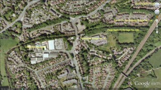
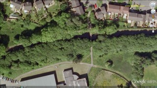
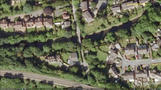
The Peak Forest Canal seen by Google Earth.
|
| Le Canal de Peak Forest vu par Google Earth. |
15-07-2006
Click to enlarge - Cliquer pour agrandir |
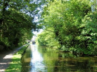
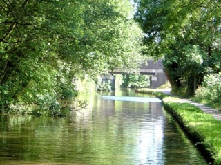
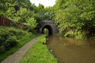
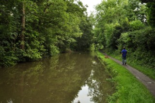
Looking to the North, the Peak Forest Canal to the South of Holehouse Bridge No.14.
|
| Les regards portés vers le Nord, le Canal de Peak Forest au Sud du Pont n°14 d'Holehouse. |
15-07-2006
Click to enlarge - Cliquer pour agrandir |
8-08-2010
Click to enlarge - Cliquer sur l'image pour agrandir |
|
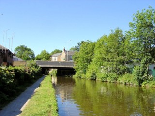
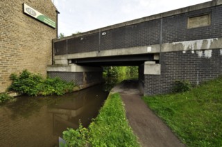
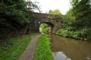
Holehouse Bridge No.14 seen from the South. |
Le Pont n°14 d'Holehouse vu du Sud. |
8-08-2010
Click to enlarge - Cliquer sur l'image pour agrandir |
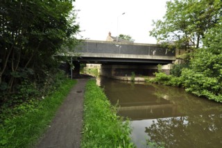
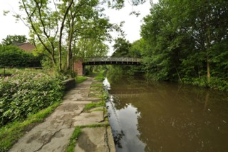
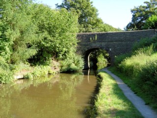
Holehouse Bridge No.14 seen from the North.
|
| Le Pont n°14 de l'Holehouse Bridge No.14 vu du Nord. |
Click to enlarge - Cliquer sur l'image pour agrandir |
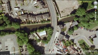
Holehouse Bridge No.14 seen by Google Earth.
|
| Le Pont n°14 de l'Holehouse Bridge No.14 vu par Google Earth. |
15-07-2006
Click to enlarge - Cliquer pour agrandir |
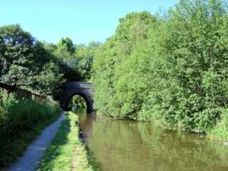
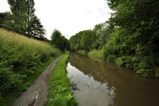
Looking to the South, the Peak Forest Canal to the North of Holehouse Bridge No.14.
|
| Les regards portés vers le Sud, le Canal de Peak Forest au Nord du Pont n°14 de l'Holehouse Bridge No.14. |
8-08-2010
Click to enlarge - Cliquer sur l'image pour agrandir |
Looking to the North, the Peak Forest Canal to the South of Peak Bank Footbridge No.13B.
|
| Les regards portés vers le Nord, le Canal de Peak Forest au Sud de la Passerelle n°13B de Peak Bank. |
15-07-2006

Click to enlarge - Cliquer pour agrandir |
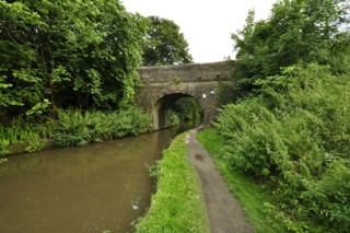
Peak Bank Footbridge No.13B seen from the South.
|
| La Passerelle n°13B de Peak Bank vue du Sud. |
8-08-2010
Click to enlarge - Cliquer sur l'image pour agrandir |
Peak Bank Footbridge No.13B seen from the North.
|
| La Passerelle n°13B de Peak Bank vue du Nord. |
Click to enlarge - Cliquer sur l'image pour agrandir |
Peak Bank Footbridge No.13B seen by Google Earth.
|
| La Passerelle n°13B de Peak Bank vue par Google Earth. |
15-07-2006
Click to enlarge - Cliquer pour agrandir |
8-08-2010
Click to enlarge - Cliquer sur l'image pour agrandir |
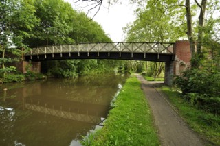
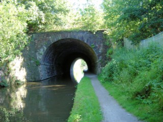
|
Top-O'-Th'-Hill Railway Bridge No.13A seen from the South. |
Le Pont Ferroviaire n°13A de Top-O'-Th'-Hill vu du Sud. |
15-07-2006
Click to enlarge - Cliquer pour agrandir |
8-08-2010
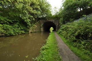
Click to enlarge - Cliquer sur l'image pour agrandir |
|
Top-O'-Th'-Hill Railway Bridge No.13A seen from the North. |
Le Pont Ferroviaire n°13A de Top-O'-Th'-Hill vu du Nord. |
Click to enlarge - Cliquer pour agrandir |
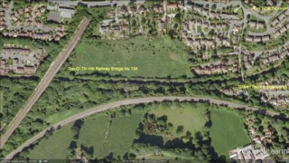
The Peak Forest Canal seen by Google Earth.
|
| Le Canal de Peak Forest vu par Google Earth. |
15-07-2006
Click to enlarge - Cliquer pour agrandir |
8-08-2010
Click to enlarge - Cliquer sur l'image pour agrandir |
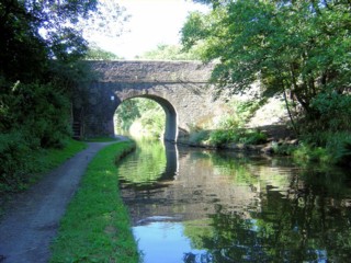
|
Gilbert Bank Bridge No.13 seen from the South. |
Le Pont n°13 de Gilbert Bank vu du Sud. |
15-07-2006
Click to enlarge - Cliquer pour agrandir |
8-08-2010
Click to enlarge - Cliquer sur l'image pour agrandir |
|
Looking to the West, the Peak Forest Canal to the West of Burymewick Aqueduct. |
Les regards portés vers l'Ouest, le Canal de Peak Forest à l'Ouest du Pont Canal de Burymewick. |
Click to enlarge - Cliquer sur l'image pour agrandir |
Gilbert Bank Bridge No.13 seen by Google Earth.
|
| Le Pont n°13 de Gilbert Bank vu par Google Earth. |
8-08-2010
Click to enlarge - Cliquer sur l'image pour agrandir |
Looking to the South, the Peak Forest Canal seen from Gilbert Bank Bridge No.13.
|
| Les regards portés vers le Sud, le Canal de Peak Forest vu du Pont n°13 de Gilbert Bank. |
8-08-2010
Click to enlarge - Cliquer sur l'image pour agrandir |
Looking to the North, the Peak Forest Canal seen from Gilbert Bank Bridge No.13.
|
| Les regards portés vers le Nord, le Canal de Peak Forest vu du Pont n°13 de Gilbert Bank. |
|
Visitez/Bezoek/Visit
Click on the image - cliquer sur l'image |
|
Peak Forest Canal |
|
|